All about earthquakes: what is magnitude, what does Richter mean and how does it apply to Ukraine
A series of powerful earthquakes in Turkey has stirred a wave of interest in “applied seismology”. Ukrainians began to remember the earthquakes of 1977, 1986, 1990 and 2004, which were felt even in central Ukraine. But it turns out that many people, especially our media and “opinion leaders”, do not understand the difference between rating an earthquake according to an intensity scale and measuring the strength of earthquakes by magnitude. The fact that different countries use different standards for the first and second scales, and there are several versions of both, adds to the confusion. Let’s figure it out!
Earthquake intensity
The intensity of an earthquake is the estimated power of the phenomenon, which is “measured” by its impact on the surface of the earth, people and buildings. Intensity is assessed by consequences visually and/or by interviewing eyewitnesses. This is an estimated and imprecise scale and it is the one most often used by mainstream media.
For example, if we refer to the European macroseismic scale (EMS-98), which was adopted in 1998, if the authorities and residents report light damage to buildings, that is, cracks in the plaster and falling of small objects – this is an earthquake of 6 points. But if most of the objects fall from the shelves, there are small cracks on the walls, and some of the chimneys are falling apart – this means 7 points. But the size of the cracks or the number of fallen objects are relative values, everyone perceives them personally. What for one is a small crack in the plaster, for another is extensive damage to their cozy home.
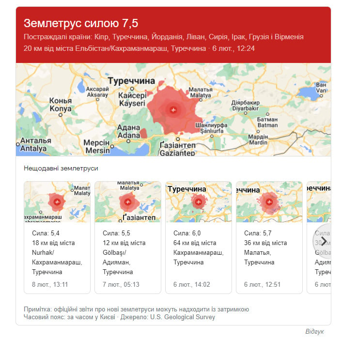
There are 12 points in the European macroseismic scale. According to it, the recent earthquake in Turkey can be estimated at 9 points, it is a destructive earthquake – monuments and columns fall; many buildings are partially destroyed, some are completely destroyed.
In the USSR, the Medvedev–Sponheuer–Karnik scale (MSK-64), adopted in 1964, was used. It is also evaluative, and the “Ukrainian” (the quotation marks here are because these earthquakes occurred outside of Ukraine, we only heard of them) earthquakes of 1977, 1986, 1990, and most likely 2004, were evaluated according to it. This is also a 12-point and rating scale.
The Medvedev–Sponheuer–Karnik scale is tied to some outdated concepts that are no longer relevant today. For example, to the pendulum of a floor/wall clock stopping (does anyone still have such a clock?), to the distortion of wooden houses (reality of the USSR/Russia), to the distortion of railway tracks, etc. All Russian-language mass media, even in Ukraine, continue to use this outdated scale. According to the Medvedev–Sponheuer–Karnik scale, an earthquake in Turkey is somewhere between 9 and 10 points. A devastating or destructive earthquake.
The United States also has its own scale for assessing the intensity of an earthquake, the Mercalli scale. It is also 12-point, was introduced in 1902, now its modified version is used. For example, 8 Mercalli points are: “Damage slight in specially designed structures; considerable damage in ordinary substantial buildings with partial collapse. Damage great in poorly built structures. Fall of chimneys, factory stacks, columns, monuments, walls. Heavy furniture overturned…”. But here there is a question about the definition of ordinary and poorly built buildings, that is, the assessment may differ depending on the observer. Earthquake in Turkey on this scale gets 9 points.
But Japan, which, by the way, suffers from earthquakes more than Europe, the USSR or the USA, uses its own 10-point seismic intensity scale of the Japan Meteorological Agency (JMA), but the limit value in it is 7 points, because it starts with 0 points, and contains another 5 points, 5+ points, 6 points and 6+. That is, if in Europe 7 points means “many people are scared and run out of buildings”, then 7 points in Japan is total destruction. According to the JMA scale, the Turkish earthquake is 6-/6+ points, there is no clear analogy.
Ukraine uses a 12-point seismic intensity scale according to DSTU B V.1.1-28:2010. This seismic scale was developed in connection with the cancellation of the MSK-64 scale in Ukraine and the need for adaptation to the European macroseismic scale EMS-98, introduced in 2011.
Let’s make it simple. If you see the word “points” – this is a rating scale for the intensity of an earthquake, it is very approximate, it does not and cannot have fractions, only whole numbers, and such a scale is tied to a specific country or region.
So, the rating scales of earthquake intensity have been dealt with. Let’s move on to measurements.
Magnitude scales
Magnitude scales are used to scientifically measure the power of an earthquake, based on the magnitude, which characterizes the energy power of this natural phenomenon. This is no longer surveying the destruction and interviewing eyewitnesses, but accurate measurements… but there are nuances.
First, there are several types of magnitudes and, surprise, surprise!, several magnitude scales: local magnitude (best known as the Richter scale), surface wave magnitude, volume wave magnitude, moment magnitude (Kanamori scale). All magnitude scales are logarithmic, that is, there are no values here, not even points. These are just numbers.
As a reminder, the logarithmic scale is convenient for displaying very large ranges of values, in addition, for many senses, the magnitude of the sensation is proportional to the logarithm of the effect. For example, exposures in photography have a logarithmic scale, pH level and sound power too.
The Richter scale of local magnitude is the most well-known, but… already outdated. Firstly, it was proposed back in 1935. Second, Charles Richter randomly chose an earthquake magnitude of 0 to avoid negative values, but modern, more sensitive seismographs easily register negative magnitude earthquakes. Thirdly, it is tied to a specific model – the Wood-Anderson torsion seismograph, which, in turn, is also outdated. Due to a design limitation, the Wood-Anderson seismograph cannot record events of magnitude greater than 6.8. But most importantly, the Richter scale is difficult to correlate with the physical characteristics of an earthquake.
The local magnitude is equal to the decimal logarithm of the displacement A (in micrometers) of the needle of a standard Wood-Anderson seismograph, located at a distance of no more than 600 km from the epicenter of the earthquake plus a correction function determined by the table depending on the distance to the epicenter. That is, taking into account the approximate function from the correction table and the distance limitation, this is not the most accurate measurement.
Nevertheless, the refined Richter scale, which includes the entire range of measurements, is still used. And it is it, without adding the word points, that is used by serious Western media, but not always.
Instead of the local Richter magnitude, seismologists suggest using, especially for powerful earthquakes, moment magnitude, which is based on the concept of seismic moment. It was proposed in 1977 by seismologist Hiro Kanamori from the California Institute of Technology.
Moment magnitude characterizes the amount of energy released at the epicenter of the earthquake and is proportional to the logarithm of the maximum displacement amplitude of soil particles recorded by seismic stations. Mathematically, it is 2/3 of the difference between the logarithm of the seismic moment (rock displacement modulus (of the order of 30 GPa) per area on which geological faults were recorded, and the average displacement along the faults) and a coefficient of 9.05. The maximum magnitude of an earthquake is about 10.6, which corresponds to an energy of 10 to the 19th power J. At such a magnitude, the earth’s crust should fall apart and we will all die.
Since 2002, the U.S. Geological Survey has used the moment magnitude to estimate strong earthquakes.
There is a formula for converting the moment magnitude of an earthquake into TNT equivalent. For example, the recent 7.9 earthquake in Turkey had the energy of an explosion of about 15 million tons of TNT, or 1,200 nuclear bombs, dropped on Hirosima in 1945. But, let’s recall, this is the energy at the epicenter of the earthquake, underground, it has a fairly relative correlation to how these and other specific buildings will behave on the surface.
Let’s make it simple. If you don’t see the word “points” and see a fraction part, this is the measured strength of the earthquake, its magnitude. But it is more difficult to say if it is according to Richter or Kanamori. Most likely, if the magnitude is up to 5 points, it is Richter, higher – Kanamori. But this is not accurate.
Earthquakes
Hundreds and hundreds of earthquakes occur every day. The Turkish earthquake is several hundred aftershocks of various magnitudes. It is estimated that around 10,000 magnitude 2 to 2.9 earthquakes occur every day (no, not the points, forget the points). Even noticeable earthquakes with a magnitude of up to 6 (again, not points) occur somewhere between 1,000 and 1,500 per year. Strong earthquakes, magnitude up to 7 – 100-150 per year. From 7 to 7.9 – about 10-20 per year. Earthquakes from 8 to 8.9 occur almost every year. Earthquakes with a magnitude greater than 9 are already a real disaster that occurs once every 10-50 years.
The magnitude of an earthquake does not always correspond to its destructive force and the number of victims. There are a lot of factors here, starting from the depth of the epicenter to rocks, the population of the area, the depth of water bodies, etc.
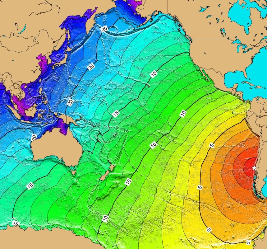
So, the most powerful earthquake ever observed – the Great Chilean or Valdivia earthquake of 1960, had a magnitude of 9.4-9.6 on the Kanamori scale. It is estimated that between 1,000 and 6,000 people died as a result of this earthquake. The tsunami destroyed even the coast of Japan and Hawaii, killing people thousands of kilometers from the epicenter. Among the consequences were volcanic eruptions, landslides, floods, etc.
But the much weaker earthquake in Tangshan (China) in 1976, the magnitude of which was only 7.6, is considered the most deadly. The earthquake struck densely populated areas of China, and according to official figures alone, 242,769 people were killed and another 164,851 were injured. According to independent data, up to 655,000 people could have died.
227,898 people died in the 2004 Indian Ocean earthquake, most killed by the devastating tsunami. The magnitude of this earthquake was 9.1 on the Kanamori scale.
And the Great Alaskan earthquake of 1964, the strongest earthquake in the United States and the second most powerful in the entire history of observations, had a magnitude of 9.2, but killed only 131 people, and almost all except 9 who died from the aftershocks, were killed by tsunami. If the same earthquake happened, for example, in New York, the number of victims would amount to hundreds of thousands of people.
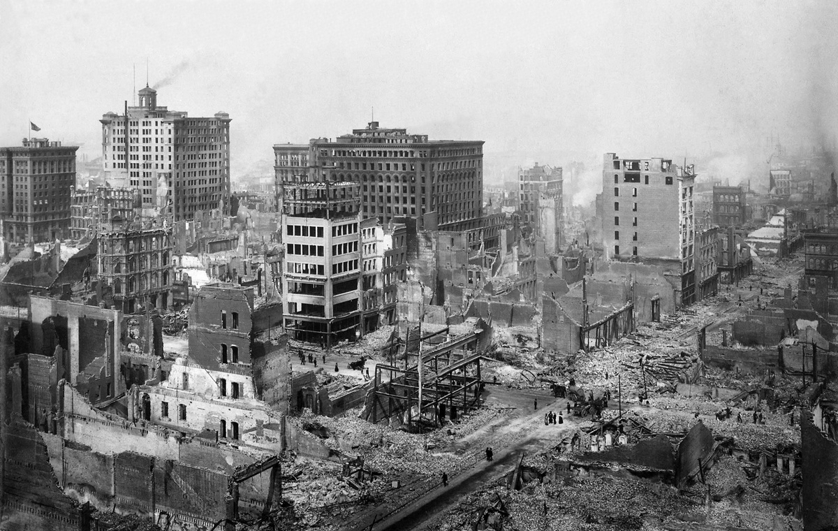
One of the most famous earthquakes, in San Francisco in 1906, had a magnitude of 7.9 on the Kanamori scale, the same as the one that had just hit Turkey, killing between 700 and more than 3,000 people and completely destroying the city.
What about Ukraine?
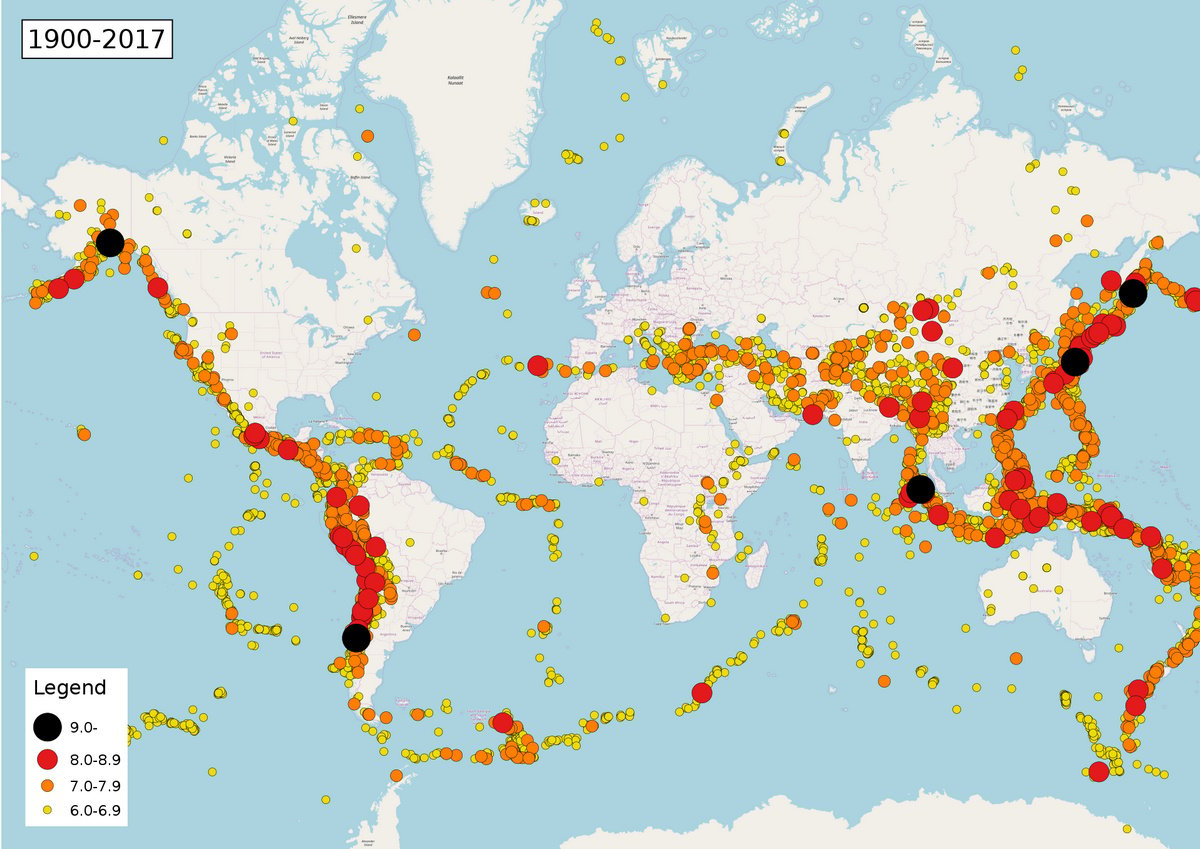
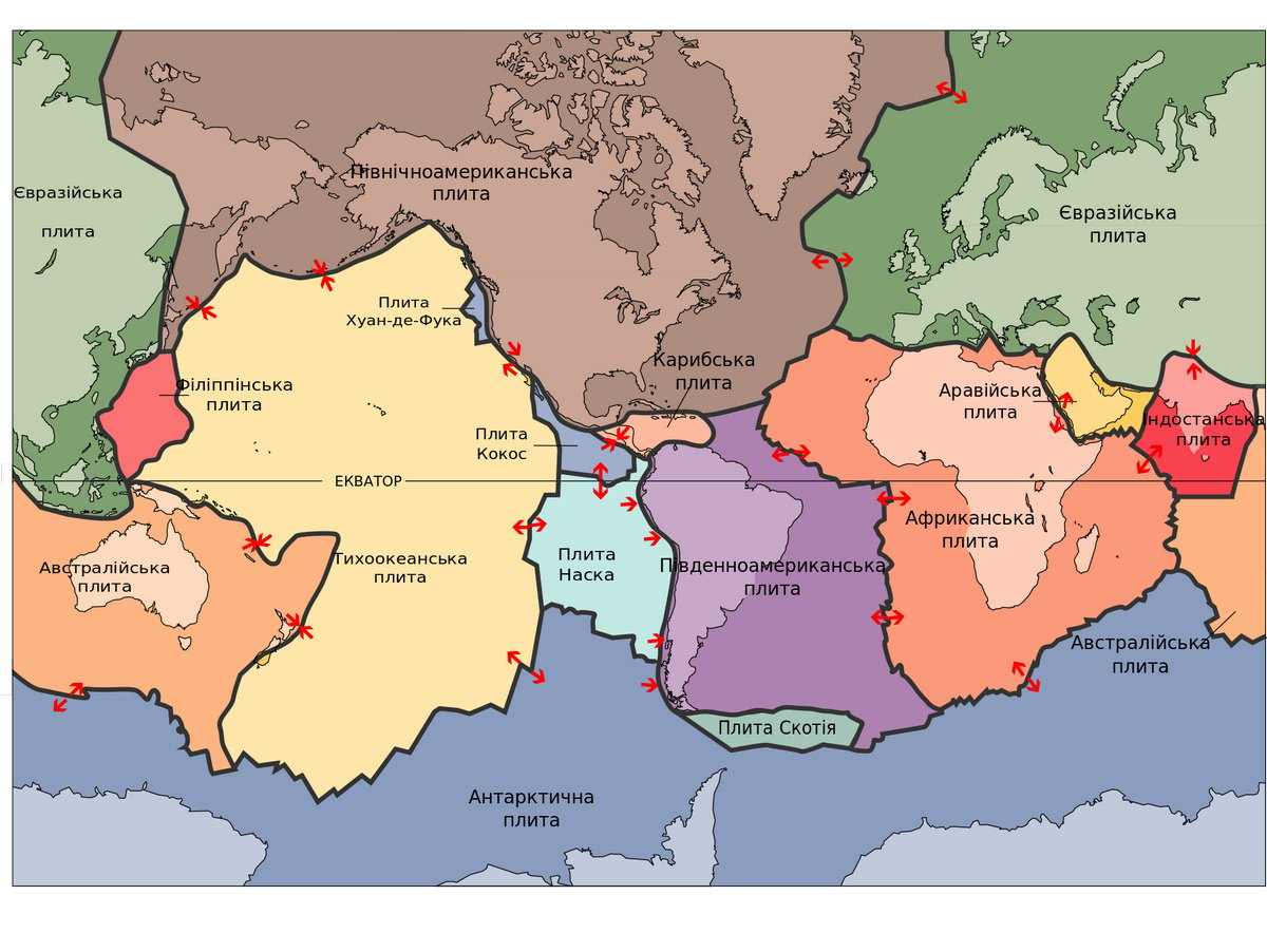
If you look at the map of the largest earthquakes in the last 100 years, it is easy to see that their epicenters are located at the junctions of the lithospheric plates. It is logical that where one plate pushes or slides under/over another, excess stress is released through earthquakes.
And here we are lucky. Ukraine is located on the Eurasian lithospheric plate, the thickest and almost the largest of all plates. The thickness of the earth’s crust on the entire territory of Ukraine is about 40 km, in contrast to 10 km for oceanic plates. What’s more, in the center of our country lies the Ukrainian Crystalline Masiff – a blocky rise of the crystalline foundation of the East European Platform. The crystalline shield is characterized by reduced heat flow and increased (up to 150 km) thickness of the lithosphere.
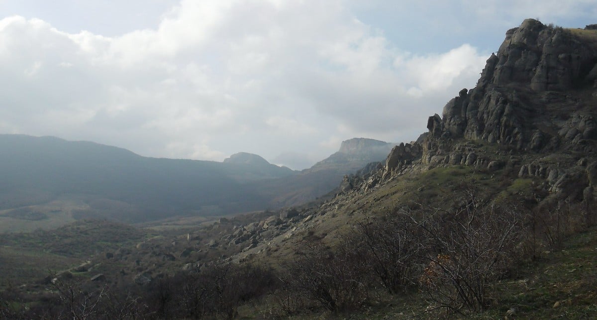
The plates closest to us, which are usually considered as components of the Eurasian plate, are the Adriatic, Aegean and Anatolian plates. That is, these are the potential zones of powerful earthquakes closest to us. In general, the region closest to us, where large earthquakes were recorded, is Romania. Earthquakes in Crimea are usually less powerful and occur quite rarely.
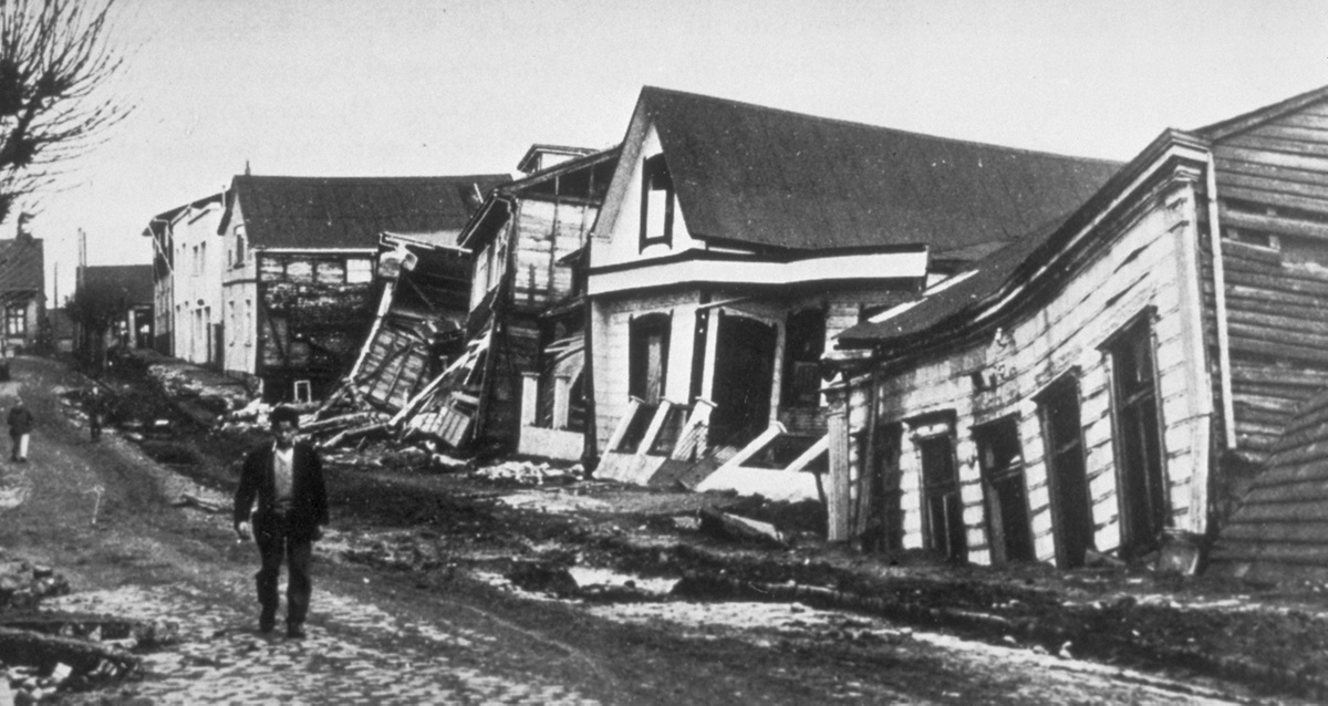
The Crimean earthquakes of 1927, which are usually combined into one seismic event, are considered the largest earthquakes on the territory of Ukraine. There were at least three powerful aftershocks from July to September 1927. The most powerful, on September 11, 1927, had a magnitude of 6.7. There were numerous collapses and landslides in the mountains, the destruction of buildings, including historical monuments, in Alushta, Alupka, Sevastopol and Simferopol. 12 people died. Note that at that time Crimea was part of the RSFSR, there was no such nonsense in Ukraine!
The so-called Vrancea Zone at the junction of the Southern and Eastern Carpathians is seismically active. The most powerful earthquakes in this zone occurred on the territory of Romania – the Carpathian earthquake of 1940 with a magnitude of 7.7 (65,000 houses were destroyed, 1,671 people died) and the Vrancea earthquake of 1977 with a magnitude of 7.5 (1,700 dead). The last earthquake was felt even in Kyiv somewhere at the level of 4 points on the MSK-64 scale.
That is, you probably already understood, Ukraine is not a seismically active zone, all we can feel are echoes and aftershocks from earthquakes in other zones, most likely in Romania. Small earthquakes can also occur in the Carpathians. An earthquake is more likely in Crimea, but no major tectonic events have occurred there in the last 100 years. 4-5 points according to MSK-64 in Kyiv in 1977, 1986, 1990, 2004 are either “Recognizable by light rattling and shaking of objects, dishes and windows, creaking of doors and walls” or “General shaking of the building, shaking of furniture; clock pendulums stop; cracks in the windows and plaster, slamming doors.” That is, without the destruction of buildings.
Where to watch for earthquakes
You can use Google! If you make a search query with the word “earthquake”, then the search will bring up separate data on the recent largest earthquakes ahead of other results. If you specify the request, for example, “earthquake in Turkey”, the information will be more detailed.
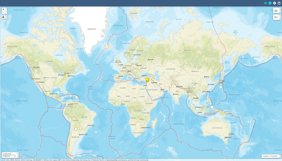
Alternatively, you can look at the US Geological Survey interactive map, which displays all recent earthquakes with a magnitude greater than 2.5.
There is an earthquake map, also with detail for Europe, on the website of the European Mediterranean Seismological Center. But it’s a little inconvenient and outdated in terms of UI.
And finally, here’s a video of 120 years of earthquakes from the Pacific Tsunami Warning Center. The video shows all earthquakes with a magnitude greater than 6.5 from 1901 to 2020, and their tsunamis, of course.
And we hope that this article will calm the citizens of Ukraine a little and teach them to distinguish the estimated intensity of an earthquake from the measured magnitude of an earthquake. Believe me, earthquakes are not our biggest problem right now.
Stay safe, believe in the Armed Forces of Ukraine!