

ICEYE satellite technologies will allow taking pictures of the territory of Ukraine despite cloudiness, rain, snow, fog, smoke or night time. The company owns more than 18 satellites, which, flying over Ukraine, can collectively take about 36 pictures per day. The technical details of the agreement were revealed today by the Serhiy Prytula Charitable Foundation and the founder of EOS Data Analytics Max Polyakov, who helped with the organization of the deal.
"Thanks to the purchase of the ICEYE satellite, Ukrainian satellite capabilities are strengthened: in combination with the GEOSAT 2 optical satellite, our country gains an advantage in space data analysis. Such a combination of technological means with the capabilities of professional analytics is a step towards the technologicalization of not only Ukraine's defense capabilities, but also the recovery of the economy after the Victory," Polyakov commented on the agreement.
Satellite SAR images are created using radio waves that are sent from the satellite to Earth, reflected off the surface, and returned to the satellite's sensors. Unlike optical satellites, radar satellites themselves "illuminate" objects with radio waves, so they do not depend on weather conditions. Depending on the surface material, objects will reflect the same radio wave differently. Due to this difference, certain objects in the pictures come out brighter, and others - darker.
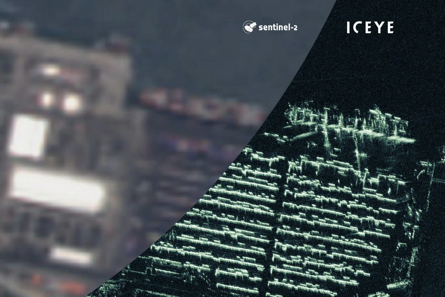
For the analysis of images received from SAR satellites, a critical condition is the presence of specialists who have experience working with this type of images. There are not so many such specialists in the whole world, but in Ukraine there are, and they continue to develop their expertise. The process is really completely different from the analysis of images received from optical satellites, and is actually carried out "manually" by the eyes of a specialist. Such a specialist must develop a specific "SAR-vision", because an image from a SAR satellite is a graphic interpretation of reflected radio waves, which has a different physics of the process, unlike "ordinary" optical images. Instead, in addition to human resources, AI technologies and neural networks are used to process a large array of data from optical satellites.
"The agreement between ICEYE and the Serhiy Prytula Charitable Foundation is an important step for strengthening Ukraine's space capabilities. First, only a limited number of countries have SAR satellites at their disposal, thanks to which Ukraine gains a competitive advantage in receiving data. Ukraine will receive them in a mode close to real time, thanks to which the time from ordering to receiving data will be reduced to hours. Secondly, the satellite is already in orbit, that is, there is no need to wait for its launch, and the images are immediately analyzed and used as intended. Thirdly, Ukraine will receive images as long as the satellite continues to work", Nik Kowalskyi, head of EOS SAR at EOS Data Analytics, explained the details of the agreement.
Technical characteristics of the ICEYE satellite received by Ukraine and details of the agreement:
- Owning the ICEYE satellite allows Ukraine to receive exclusive images continuously, guaranteed and 24/7 under any weather conditions;
- According to the agreement, the Ukrainian side receives both the satellite and access to the satellite constellation database;
- When the paid period of access to the database expires, the indicated satellite remains in full ownership of Ukraine - until the end of its functionality in orbit;
- The acquired satellite works over the territory of Ukraine exclusively to achieve the goals and tasks of the Ukrainian Armed Forces. At the time when the satellite is not over the territory of Ukraine, we can receive data thanks to access to the constellation of SAR satellites of the ICEYE company. Access is guaranteed;
- According to the agreement, the satellite is insured and guaranteed by ICEYE. In the event of a technical malfunction, the seller company undertakes to provide the Ukrainian side with an identical satellite;
- SAR technology allows you to take pictures both during the day and at night, when it is cloudy (which is relevant for our country in the off-season and in winter, because in Ukraine there can be up to 20 cloudy days per month, sometimes cloudy periods stretch for more than 2 weeks), during fogs and other weather phenomena. Radio waves from such satellites are able to penetrate smoke and ash as well. Thus, the satellite can provide images around the clock;
- Satellite images of the territory of our country are received only by the Ukrainian side as the owner of the satellite, therefore access is exclusive;
- Frequency of flights: the satellite flies over our territory twice a day;
- Ukraine has the opportunity to receive pictures at other times from other SAR satellites of the ICEYE constellation, which also fly over Ukraine every day. In this way, the continuity of receiving data is ensured;
- Resolution: from 0.5 meters to 1 meter depending on the area covered by the picture;
- The satellite operates in a sun-synchronous orbit. In 24 hours, the satellite makes 15 revolutions around the Earth, moving at a speed of 7.5 km per second. The satellite is located at an altitude of 500-600 km above the Earth's surface;
- Characteristics of pictures: 1 picture can cover an area of up to 225 square kilometers;
- Speed of data acquisition: foreign partners do provide Ukraine with satellite images, but usually with a significant delay.
Due to the fact that Ukraine bought the satellite, the process of data transfer from the moment of the image to the moment when it is received directly by military units is reduced to a few hours. In the conditions of war, the speed of obtaining information is a significant advantage.